
Skydiving Altitude: MSL vs AGL and Density Altitude
Compare MSL, AGL and density altitude in skydiving. Work through ground-elevation examples and see why terrain and altitude references must stay together.
By ActionSportsHQ Editorial · Published · 6 min read
At a glance
- MSL uses mean sea level as a reference while AGL refers to height above the ground at a specified location.
- Adding ground elevation to height above that same ground works only when units and vertical references match.
- Density altitude describes atmospheric density relative to a standard atmosphere; it is not extra geometric height above the terrain.
MSL altitude is referenced to mean sea level; AGL height is referenced to specified local ground. Subtracting that ground’s MSL elevation from a point’s MSL altitude gives its height above that ground when units and vertical datum match. Density altitude describes an atmospheric-density comparison rather than additional geometric height.
The invented elevation diagrams below explain how the references change across terrain. None of the example heights specifies an exit, deployment, decision or emergency altitude; those belong to the actual equipment and operational briefing.
One point can have two correct vertical descriptions
USPA’s training material distinguishes altitude referenced to sea level, the elevation of a ground location, and height above ground. 1 A number can change when its zero changes even though the physical point stays in the same place.
Imagine a simplified flat landscape at 1,000 ft MSL and an unnamed point 3,000 ft above that ground. Both values are exact assumptions for this exercise, not measurements:
1,000 ft ground elevation + 3,000 ft above that ground = 4,000 ft MSL.
Reversing the comparison gives 4,000 − 1,000 = 3,000 ft AGL. At the ground plane itself the corresponding descriptions are 1,000 ft MSL and 0 ft above that same ground.
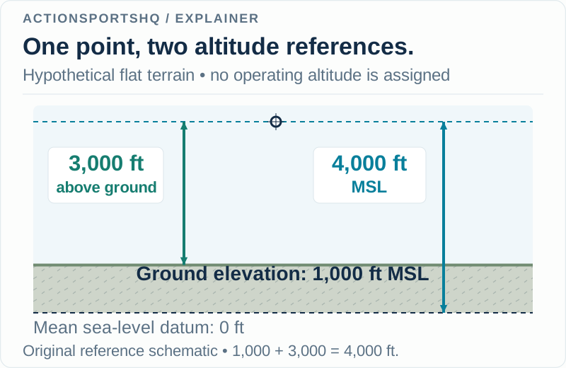
The addition works because both segments are vertical distances expressed in feet along the same reference stack. Combining feet with metres without conversion, or using an elevation for a different ground location, would break that stack.
The formula does not need an ocean directly below the landscape. Mean sea level supplies a vertical reference, not a statement about what surface is currently underneath the point. Conversely, being over land does not automatically make an altitude AGL.
The ground reference changes across terrain
Keep the invented point’s level at 4,000 ft MSL, but compare it with three different terrain elevations:
| Ground directly below the point being compared | Ground elevation | Difference from 4,000 ft MSL |
|---|---|---|
| Flat area A | 1,000 ft MSL | 3,000 ft above that ground |
| Higher ground B | 1,800 ft MSL | 2,200 ft above that ground |
| Lower ground C | 600 ft MSL | 3,400 ft above that ground |
These are separate hypothetical columns, not a flown route. The MSL level stays the same while the ground clearance changes. A height referenced to area A cannot simply be copied over B and renamed “height above the terrain below.”
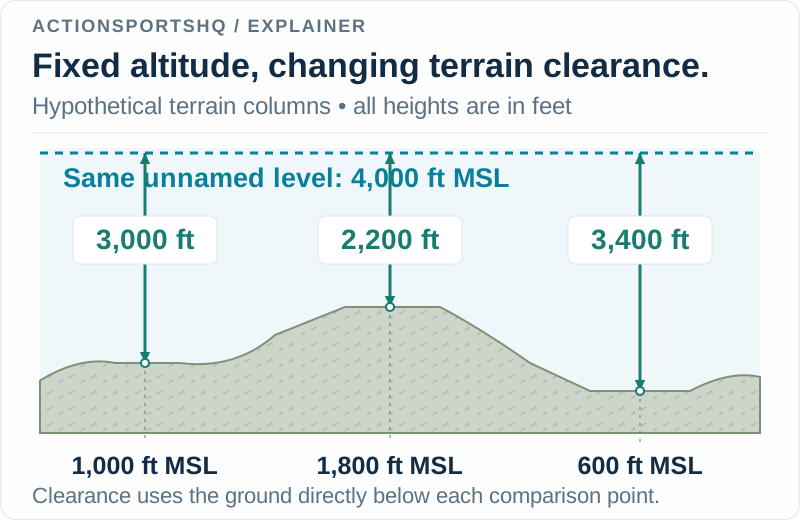
This reveals a useful question to ask about any “above ground” value: which ground? It may refer to the field used as the local reference, while your intended comparison concerns a different surface. State the location before doing the subtraction.
A map elevation is also a point or mapped-surface value, not an automatic measurement of every obstacle. A terrain comparison alone therefore cannot establish separation from a building, tree or other object. The example contains no obstacle or clearance assessment.
Keep instruments separate from the geometric example
The diagrams show ideal geometric relationships. They do not identify how a particular device determines altitude, what reference it has been configured to use or what errors affect its reading. A value appearing on a screen is not self-describing.
For an equipment discussion, bring the exact device model and its instructions to the instructor. Useful interpretation questions include “what is this display referenced to?”, “which unit is shown?” and “does this number use the field reference or another datum?” The answers belong to the actual system and briefing.
Do not change a setting from an online example to make it resemble the diagram. A teaching diagram has no knowledge of the equipment, current location or operational plan. For a first tandem skydive, the operator’s ground briefing is the place to resolve how altitude language is being used.
Density altitude is a different kind of reference
The FAA describes pressure altitude using a standard pressure reference and density altitude as pressure altitude corrected for nonstandard temperature. It explains density altitude as the equivalent standard-atmosphere altitude for a given air density. 2
That is an atmospheric comparison, rather than another geometric segment to add to the picture. Imagine two classroom descriptions of the same point and terrain on different days. The point and terrain retain their stipulated elevations, but different atmospheric conditions can produce different density-altitude values.
Writing “AGL + density altitude = MSL” would mix unlike quantities. Density altitude is also not a replacement elevation for the ground. If the field has not moved, a change in the atmosphere has not moved the field’s sea-level reference.
| Quantity | Kind of question it helps describe | What it is not |
|---|---|---|
| MSL altitude | Where a point sits relative to a sea-level datum | Height above every nearby surface |
| AGL height | Vertical distance above specified local ground | A universal zero independent of location |
| Ground elevation | Where the chosen ground sits in the datum | The air’s density |
| Density altitude | How air density compares with a standard atmosphere | Additional geometric height or an instrument-setting instruction |
Performance interpretation still requires the relevant equipment, conditions and qualified instruction. This guide deliberately supplies no canopy speed correction, flight plan or operating threshold derived from density altitude.
Label an altitude comparison so someone else can check it
Before comparing two figures, write the number, unit, reference, location and context. For a fictional classroom record, “4,000 ft MSL; terrain point A = 1,000 ft MSL; difference = 3,000 ft above A” is complete enough for another reader to verify the arithmetic.
“Altitude 4,000” is not. A second reader cannot tell whether it means feet or metres, sea-level or local reference, an assumed figure or an instrument observation. Adding a few labels supplies more value than adding decimal places to an unidentified number.
Keep this reference exercise separate from the activity sequence discussed in skydiving freefall concepts. The same habit of naming references also explains why airspeed and groundspeed can describe the same moving object differently. In each case, the reference is part of the quantity.
Sources checked 3 November 2026. The figures, examples and comparison tables are original ActionSportsHQ educational material. No operational altitude or device configuration is specified.
Reader questions
Does 0 AGL always mean 0 MSL?
No. At ground level, height above that local ground is zero. Its MSL elevation can be above or below the sea-level reference. In the invented example, ground at 1,000 feet MSL is still 0 feet above itself.
Can I subtract the drop zone's elevation everywhere to find my AGL?
Only for the ground reference that elevation actually represents. Over different terrain, height above the surface below uses that surface's elevation. A value referenced to the drop zone cannot be assumed to follow every hill and valley.
Does a higher density altitude mean the terrain has moved farther below me?
No. Density altitude expresses an atmospheric-density comparison with a standard atmosphere. It affects performance interpretation, but does not change the geometric separation between a point and the terrain. It cannot be added to AGL to calculate MSL.
Sources and scope
Each reference supports the topic stated in its scope note. Worked examples are illustrative unless identified as measured results. Use current local information and the manual for your own equipment alongside appropriate practical instruction.
- USPA Skydive School: Category D, altitude referencesMean sea level, ground elevation and above-ground-level terminology in the skydiving training context.
- FAA: Stinson 108-3 lessons learned, density altitudePressure altitude, density altitude and the standard-atmosphere reference; no accident operating figures are used here.
Continue reading
- First Tandem Skydive: What to Expect and Ask Beforehand
Prepare for your first tandem skydive with questions about eligibility, clothing, timing, weather delays, instructor briefings and what happens afterwards.
- Skydiving Basics: Freefall, Parachutes and Training
Understand skydiving freefall, drag, parachute deployment and canopy flight. Compare tandem, AFF and other student methods before choosing training.
- Paragliding Airspeed vs Groundspeed: How Wind Adds
Compare paragliding airspeed and groundspeed with headwind, tailwind and crosswind examples. Learn how velocity vectors differ from a GPS speed reading.