
Mountain Forecasts: Freezing Level, Snow Level and Cloud Base
Learn what freezing level, snow level and cloud base mean in mountain forecasts, how height references differ and why existing snow cover is a separate record.
By ActionSportsHQ Editorial · Published · 6 min read
At a glance
- Read the forecast product's definition before treating a freezing-level label as a particular temperature surface.
- Cloud base, precipitation type and existing snow cover answer different questions even when each is described by a height.
- Compare levels only after matching their vertical reference, units, forecast area and valid time.
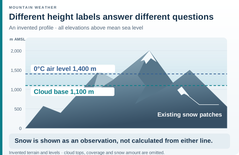
The meteorological freezing level marks the transition to below-freezing air; a mountain forecast product may use its own freezing-level definition. Snow level concerns the transition between predominantly rain and snow, while cloud base locates the lower boundary of a specified cloud layer. Existing snow cover is a separate observation. These levels can have different heights at the same time.
To compare a level with a mountain elevation, first match the provider’s definition, vertical reference, units, area and valid time. The invented examples below show why a cloud-base number, a freezing-level field and a snowline observation should stay in separate columns.
Start with the provider’s definition
The NWS glossary describes freezing level using the altitude where air temperature drops below freezing. That is an atmospheric reference, not an observation of the surface of a path. 2
Product language can differ. The Met Office’s mountain guide defines its displayed freezing level in terms of expected snow settling or frozen ground, and notes that daytime surface melting in direct sunshine is not included in that definition. It also explains that the written forecast adds cloud, visibility and variations omitted from the table. 1
Keep the product name beside the label. A field called “0°C height” and a mountain table called “Freezing Level” may look interchangeable in a notebook while carrying different definitions. Preserve the wording before trying to reconcile the numbers.
| Label | First question to ask | What the label alone cannot provide |
|---|---|---|
| Freezing level or 0°C height | How does this product define it? | A map of ice on every surface |
| Forecast snow level | Is it describing falling precipitation, settling snow or something else? | Snow depth at a specific place |
| Cloud base | Which cloud layer, coverage and vertical reference are meant? | A guarantee of clear ground below it |
| Observed snowline | When and where was the snow cover observed? | The next period’s precipitation type |
Separate falling snow from snow already on the ground
The NWS Western Region technical paper treats snow level as the elevation separating predominantly snowy from rainy precipitation, with a transition near that level. It explains why this level can differ from the air-temperature freezing level, including cooling as precipitation falls. Its regional definition also does not promise accumulation everywhere above the level. 3
Do not turn that relationship into a fixed subtraction rule. This guide deliberately supplies no “freezing level minus a certain number of metres” formula. Use the local service’s precipitation forecast and definition.
For a record, name an existing snowline separately: “snow cover visible on this aspect in an image dated Tuesday” is an observation. “Snow level forecast for Wednesday afternoon” is a prediction for a valid period. Even if the two heights happen to match, their agreement does not make them the same variable.
An image also has a footprint. A white patch in a shaded gully cannot establish continuous snow coverage on the ridge beyond it. Keep the location, aspect, observation time and visible extent with the note instead of assigning the whole mountain one snowline number.
Put every height on the same vertical reference
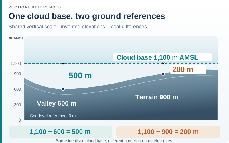
AMSL means above mean sea level. A height above ground instead starts at a specified local surface. They cannot be compared directly without knowing that surface’s elevation. The same unit does not guarantee the same reference.
Invented reference example: a valley floor is 600 m AMSL, and a cloud base is stated as 1,100 m AMSL. The vertical difference above that valley is 1,100 − 600 = 500 m. Above another point at 900 m AMSL, the difference to that same idealised base is only 200 m.
Calling the cloud base “500 m above ground everywhere” would silently extend the first valley’s reference across changing terrain. Calling it “1,100 m above ground” would make a different error: it would add the ground elevation a second time.
A point above the listed base is also not enough to establish continuous cloud there. Cloud amount, extent, multiple layers and changes over time remain separate information. Keep the text describing those features with the number.
Read a changing forecast by time, not as one daily height
Consider a second invented record. All heights below use AMSL, the same hypothetical area and the same units. These values are neither a real forecast nor a recommended mountain day.
| Valid period | Cloud base | 0°C air level | Comparison with a 1,500 m terrain point |
|---|---|---|---|
| Morning | 1,100 m | 1,400 m | Point is 400 m above the base and 100 m above the temperature level |
| Afternoon | 900 m | 1,700 m | Point is 600 m above the base and 200 m below the temperature level |
The cloud base lowers while the temperature level rises. “The levels are rising” would erase half the story. The arithmetic describes relative positions; it gives no precipitation amount, ground temperature, cloud coverage or route suitability.
Nor should the morning cloud base be paired with the afternoon freezing level and presented as a simultaneous profile. Keep each column’s valid time. If a forecast describes a range or an uncertain changeover time, record that range instead of manufacturing a precise crossing time between two entries.
Make a compact interpretation record
Use one row per question rather than copying an entire weather page into an unlabeled screenshot:
| Record field | Example of a useful entry |
|---|---|
| Product and issue | Provider, forecast region, issue time and version saved |
| Valid period | The specific period being interpreted, including the return |
| Vertical reference | Metres AMSL, or the named ground reference if used |
| Level and meaning | Exact field label, value or range, and definition |
| Terrain comparison | Named point and map elevation, kept separate from forecast data |
| Remaining question | Missing coverage, precipitation detail, uncertainty or current ground observation |
This record complements the mountain layering log, where conditions and activity phases belong together. For snow travel, a weather-height comparison also leaves the snowpack and terrain questions addressed in reading avalanche forecasts. A number above or below a summit cannot resolve those questions for a ski tour.
Sources checked 3 November 2026. The diagrams, arithmetic and record format are original ActionSportsHQ teaching material. They interpret labels and references; they do not approve a route.
Reader questions
Can cloud base be lower than the freezing level?
Yes. They describe different properties: where a cloud layer begins and an air-temperature or product-specific freezing reference. Their order can change. Compare the same time and height reference before drawing a relationship between them.
Does a falling freezing level show how much snow will accumulate?
No. A level alone does not provide precipitation amount, duration or the condition of the receiving surface. Look for the product's separate precipitation and accumulation information and its stated uncertainty rather than calculating a snow depth from height.
Is cloud base always measured above sea level?
No. Height conventions depend on the product. Identify whether a value is above mean sea level or above a particular ground reference. A missing reference is a reason to consult the provider's documentation before comparing the value with a map elevation.
Sources and scope
Each reference supports the topic stated in its scope note. Worked examples are illustrative unless identified as measured results. Use current local information and the manual for your own equipment alongside appropriate practical instruction.
- Met Office: mountain forecast guideThe mountain product's freezing-level definition and the complementary role of its written forecast.
- NOAA NWS: freezing level glossaryThe meteorological meaning of a freezing level as an air-temperature reference.
- NOAA NWS Western Region: snow level definition and methodologySnow level as a precipitation-type forecast, transition zones and the distinction from the zero-degree air level.
Continue reading
- Mountain Layering System: Base, Midlayer and Shell
Plan clothing for ascent, stops and the return. Use a downloadable layering field log and a fictional worked record to separate garment, fit and packing problems.
- How to Read an Avalanche Forecast and Danger Rating
Read avalanche forecast regions, validity, danger levels, elevation bands and aspects. Use a worked bulletin example to connect problems with route questions.
- Ski Touring vs Skimo: Skins, Gear and Transitions
Compare ski touring, ski mountaineering and skimo racing. Understand climbing skins, boot and binding modes, and how to organise a transition.